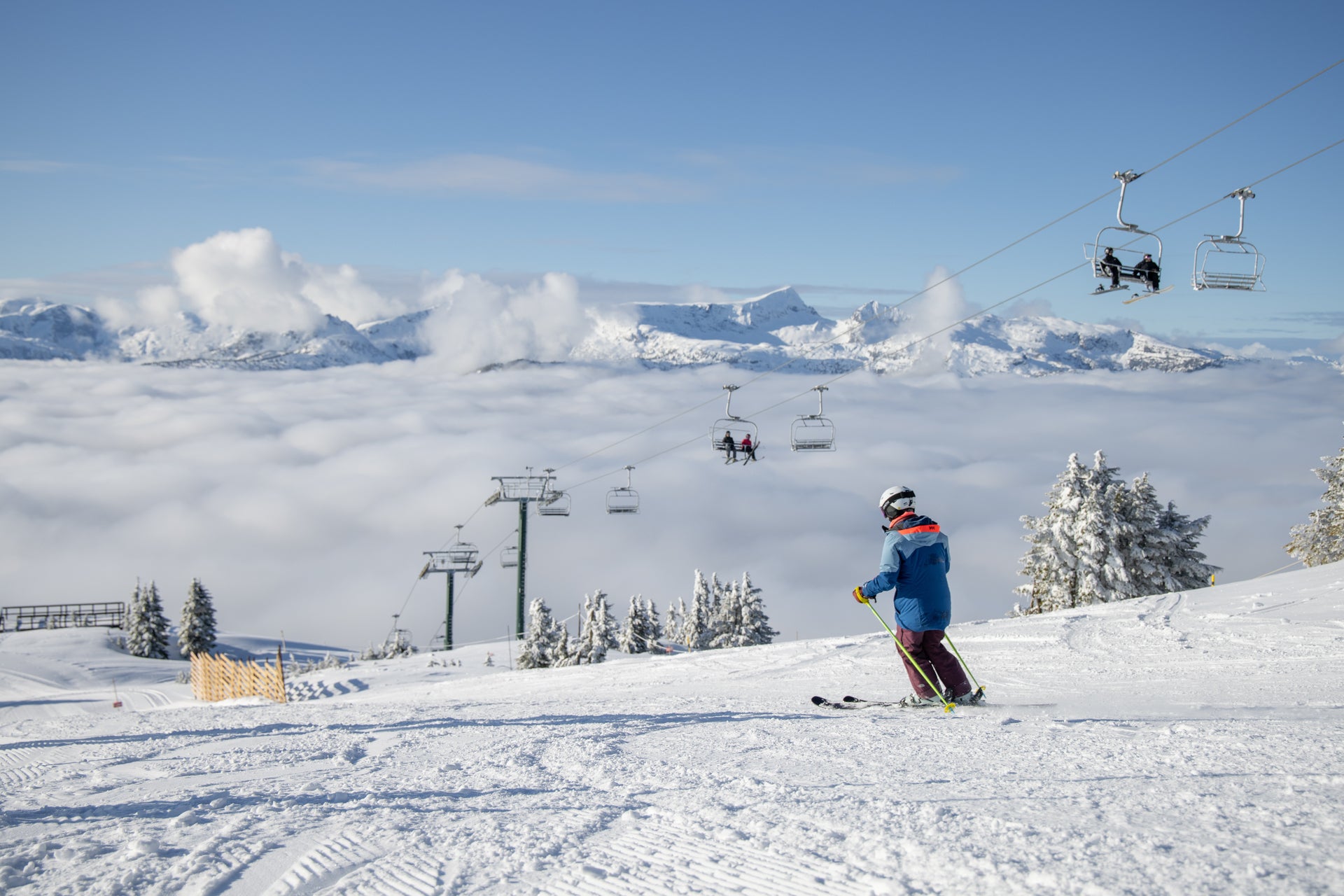
Ready to hit the ski slopes? Check out Meteorologist Chris Tomer’s North America snow forecast to find out about the weather, forecasted snow, and which ski resorts have the best odds for powder days. After your trip, leave a resort review here. Want to be notified as soon these snow forecasts are published? Subscribe to our YouTube page.
Twice-Weekly North America Snow Forecasts
by Meteorologist Chris Tomer
April 1, 2026
Tomer’s Take
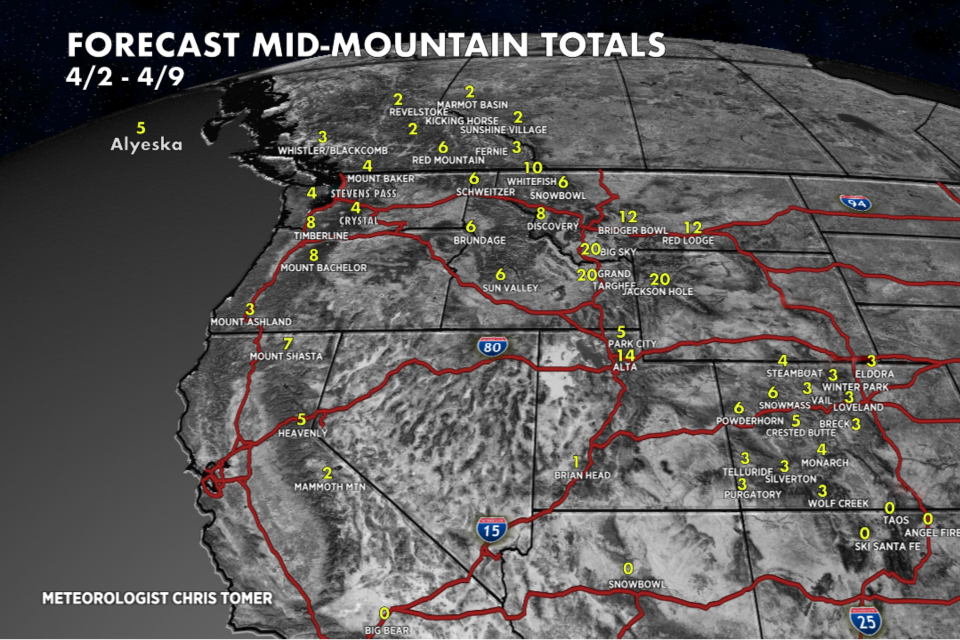
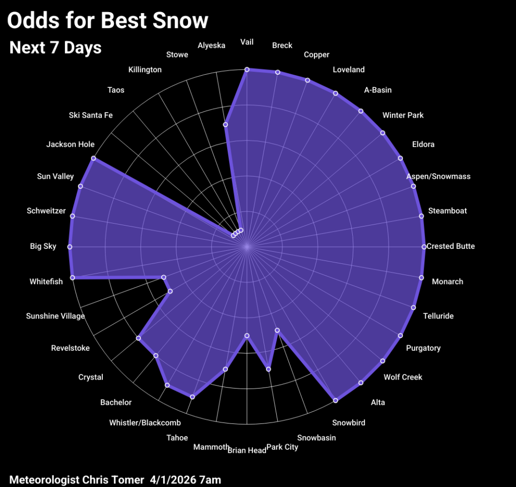
The pattern remains active across the West through 4/3 with an additional storm system 4/8-4/10, though air temps remain on the warmer side. Note: Some ski resorts, including Mt. Ashland, Mt. Shasta, and New Mexico ski resorts, have closed for the ski season, while others will be closing in the coming days. See a complete list of projected closing dates here.
Wyoming, Idaho & Montana
Moderate to heavy snow accumulation in Wyoming 4/2-4/3 and moderate to heavy snow 4/8-4/10. Total snow accumulation of 18-24 inches at Grand Targhee and Jackson Hole. In Idaho expect moderate to heavy snow accumulation into 4/2 and moderate to heavy snow 4/9-4/10. Total snow accumulation of 5-10 inches at Schweitzer, Brundage, and Sun Valley. I’m forecasting light snow accumulation for Montana resorts into 4/2, moderate snow 4/3, and moderate to heavy snow 4/8-4/10. Total snow accumulation of up to 20 inches at Big Sky with 6-12 inches at Snowbowl, Discovery, and Whitefish.
Colorado & Utah
Moderate snow accumulation in Colorado on the afternoon of 4/2 into early 4/3, light snow 4/8, and light snow 4/10. Total snow accumulation of 3-6 inches across all mountain zones. For Utah I’m forecasting heavy snow accumulation into 4/2 and moderate to heavy snow 4/9-4/10. Total snow accumulation of 5-15 inches with the higher end totals at Alta, Snowbird, Solitude, and Brighton.
Pacific Northwest & Whistler
Moderate to heavy snow accumulation for the Pacific Northwest into 4/2 and light snow 4/8. Total snow accumulation of 3-8 inches at Whistler Blackcomb, Stevens Pass, Crystal Mountain, Mt. Baker, Timberline, and Mt. Bachelor.
California
Moderate to heavy snow accumulation for California ski resorts into early 4/2 and light snow 4/8-4/9. Total snow accumulation of 2-8 inches at Lake Tahoe resorts and Mammoth.
Banff & Interior British Columbia
Light snow accumulation at Banff ski resorts 4/2 and light to moderate snow 4/8. Total snow accumulation of 2-6 inches at Sunshine, Mt. Norquay, and Marmot Basin. For Interior British Columbia resorts I’m forecasting light snow accumulation on the afternoon of 4/7 into early 4/8. Total snow accumulation of 2-6 inches, with the higher end totals at Red Mountain.
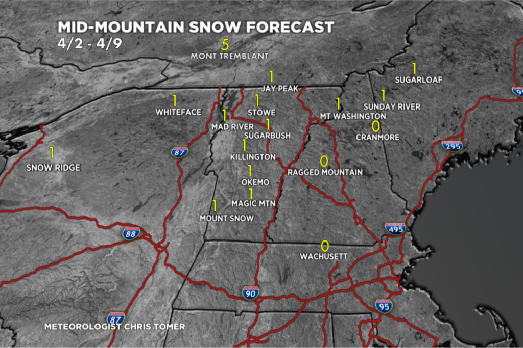
Northeast
Expect light rain showers in the Northeast 4/2-4/3, rain showers 4/6, and a chance for light snow accumulation 4/6. Total snow accumulation of 0-2 inches across most of the Northeast, with up to five inches at Mont Tremblant.
March 29, 2026
Tomer’s Take
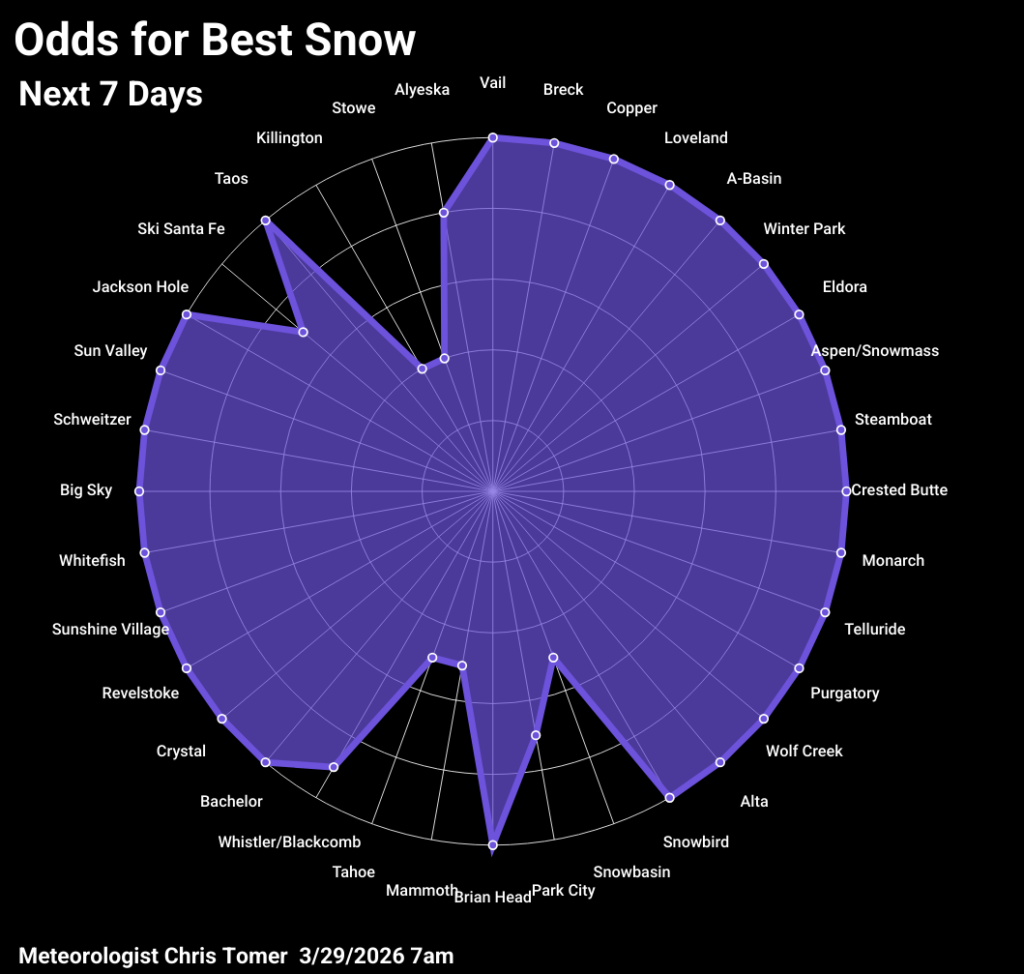
I’m forecasting two storm systems through 4/4 with colder air and moderate to heavy snow accumulation across parts of the West. In the Northeast there will be a rain/snow mix at most ski areas.
Note: Some ski resorts, including Mt. Ashland, Mt. Shasta, and New Mexico ski resorts, have closed for the ski season. See a complete list of projected closing dates here.
Pacific Northwest & Whistler
Heavy snow accumulation in the Pacific Northwest 4/1, light snow 4/2, 4/4, and 4/6, and moderate snow 4/9. Total snow accumulation of 8-16 inches at Timberline, Mt. Bachelor, Crystal, Stevens Pass, Mt. Baker, and Whistler Blackcomb.
California
Light snow accumulation at California ski resorts 3/31 and light to moderate snow accumulation 4/1-4/2. Total snow accumulation of 5-10 inches at Lake Tahoe resorts and Mammoth.
Banff & Interior British Columbia
Light snow accumulation at Banff ski resorts early 3/30, light to moderate snow 4/2, light snow 4/4, and moderate snow 4/6-4/7. Total snow accumulation of 6-12 inches at Sunshine, Mt. Norquay, and Marmot Basin. Expect moderate to heavy snow accumulation for Interior British Columbia resorts 4/5-4/7. Total snow accumulation of 6-12 inches at Revelstoke, Fernie, Kicking Horse, and Red Mountain.
Colorado & Utah
Moderate to heavy snow accumulation at Colorado ski resorts 4/1, moderate to heavy snow 4/3, and light snow 4/4. Total snow accumulation of 8-16 inches across all mountain zones. A few spots could get 20 inches. In Utah I’m forecasting light snow accumulation in Utah early 3/30, moderate to heavy snow 3/30-4/2, and light snow 4/3. Total snow accumulation of 18-24 inches at Solitude, Brighton, Alta, and Snowbird, with less at Park City, Deer Valley, and Snowbasin. Expect up to 10 inches at Brian Head.
Wyoming, Idaho & Montana
Light snow accumulation at Wyoming ski resorts 3/30, moderate snow 4/1, and heavy snow 4/2-4/3. Total snow accumulation of 15-20 inches at Grand Targhee and Jackson Hole. In Idaho expect light snow accumulation 3/30-3/31 and moderate to heavy snow 4/1-4/2. Total snow accumulation of 10-18 inches at Schweitzer, Sun Valley, and Brundage. I’m forecasting moderate to heavy snow accumulation in Montana 3/30-4/3 and light snow 4/5-4/7. Total snow accumulation of 8-16 inches at Big Sky, Snowbowl, Discovery, and Whitefish.
Northeast
Expect rain showers at Northeast ski areas 3/31, a rain/snow mix 4/2-4/3, and light snow accumulation 4/6. Total snow accumulation of 1-4 inches at most resorts. Mont Tremblant is directly in the storm track and stays colder with a foot of snow accumulation.

March 25, 2026
Tomer’s Take
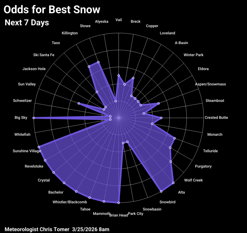
Massive high pressure and abnormally warm temperatures continue through 3/30 (with very high elevation freezing levels) then a pattern shift occurs on/after 3/31 with a couple storm systems across the West, colder temperatures, and widespread snow accumulation. The Sierra could see 1-3 feet of new snow accumulation. On 3/27 ski the Northeast, Revelstoke, or Kicking Horse. On 3/28 ski Marmot Basin. On 3/29 ski Revelstoke, Kicking Horse, Mt. Norquay, Sunshine, or Marmot Basin.
Note: Some ski resorts, such as Mt. Ashland and Mt. Shasta, have closed for the ski season. See a complete list of projected closing dates here.
Pacific Northwest & Whistler
Expect lingering snow at Pacific Northwest ski resorts into 3/26, moderate snow 3/29, and heavy snow 4/1-4/2. Total snow accumulation of 10-20 inches at Whistler Blackcomb, Mt. Baker, Stevens Pass, Crystal, and Timberline, with less at Mt. Bachelor.
California
Heavy snow accumulation in California 3/31-4/2. Total snow accumulation of 1-3 feet at LakeTahoe resorts and Mammoth.
Banff & Interior British Columbia
Expect lingering snow for Banff resorts into 3/26, moderate to heavy accumulation 3/28-3/30, and light snow 4/2. Total snow accumulation of 10-20 inches at Sunshine, Mt. Norquay, and Marmot Basin. For Interior British Columbia I’m calling for lingering snow into early 3/26, moderate snow the afternoon of 3/29 into 3/30, and light snow 4/3. Total snow accumulation of 5-10 inches at Revelstoke, Fernie, and Kicking Horse, with only an inch at Red Mountain.
Colorado & Utah
Moderate to heavy snow accumulation in Colorado from the afternoon of 3/31-4/3. Total snow accumulation of 4-12 inches in the Southern Mountains and 1-7 inches across the Central and Northern Mountain zones. For Utah I’m forecasting lingering light precipitation into early 3/26 and moderate to heavy snow accumulation 3/31-4/4. Total snow accumulation of 6-12 inches across the Wasatch, with the higher totals at Solitude, Brighton, Alta, and Snowbird. Brian Head could see a foot of new snow.
Wyoming, Idaho & Montana
Moderate to heavy snow accumulation at Wyoming ski resorts 3/31-4/3. Total snow accumulation of 6-14 inches at Jackson Hole and Grand Targhee. Expect moderate snow accumulation in Idaho 3/30-4/3. Total snow accumulation of 1-6 inches at Sun Valley, Brundage, and Schweitzer, with heavier accumulation at the highest elevations. In Montana I’m forecasting lingering snow into 3/26 and moderate snow accumulation 3/31-4/3. Total snow accumulation of 1-6 inches at Big Sky, Bridger Bowl, Discovery, Snowbowl, and Whitefish, with heavier accumulation at the highest elevations.
Northeast
I’m forecasting rain/snow at Northeast ski resorts on the afternoon of 3/26 into early 3/27, light rain/snow 3/30, and light to moderate rain/snow 3/31-4/3. Total snow accumulation of 1-6 inches across New York, Vermont, New Hampshire, and Maine.

New Mexico
Light snow accumulation at New Mexico resorts 4/1-4/2. Total snow accumulation of 1-4 inches at Taos and Angel Fire. Little to no snow at Ski Santa Fe.
March 22, 2026
Tomer’s Take
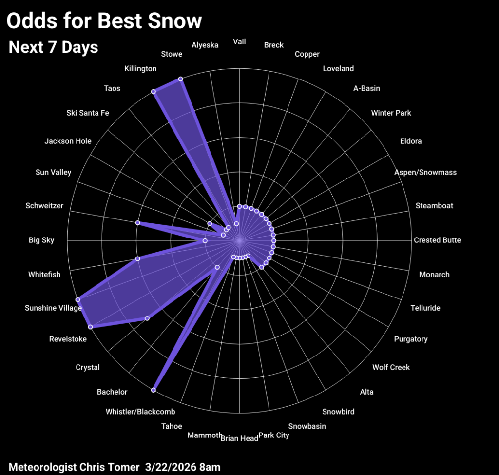
Massive high pressure remains in control of the West through 3/29 then pressures start to drop with cooler temps and better chances for new snow into the first week of April. On 3/27 ski the Northeast, Revelstoke, or Kicking Horse. On 4/1 ski the Northeast. On 4/2 ski the Northeast or Whistler/Blackcomb.
Pacific Northwest & Whistler
Heavy snow accumulation for some Pacific Northwest ski resorts 3/24 through early 3/26, as temperatures gradually turn colder. Then heavy snow again 3/29-4/4. Total snow accumulation of 1-2 feet at Mt. Baker and Whistler Blackcomb, less at Stevens Pass, Crystal, Timberline, and Mt. Bachelor.
Banff & Interior British Columbia
Moderate snow accumulation at Banff ski resorts 3/24, light snow 3/25, and light to moderate snow 3/26. Total snow accumulation of 6-10 inches at Mt. Norquay, Sunshine, and Marmot Basin. Expect moderate to heavy snow accumulation at Interior British Columbia resorts 3/24-3/26 and moderate snow 3/30-3/31. Total snow accumulation of 8-16 inches with higher end totals at Revelstoke, Kicking Horse, and Red Mountain.
Colorado & Utah
I’m forecasting moderate snow accumulation in Colorado 3/30-4/2. Total snow accumulation of 0-3 inches across all mountain zones through 3/30. Expect light snow accumulation in Utah early 3/26 and moderate snow 3/30-4/2. Total snow accumulation of 0-3 inches across the Wasatch through 3/30.
Northeast
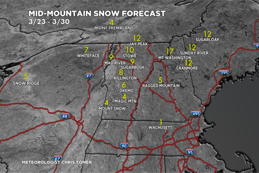
I’m forecasting light snow accumulation for the Northeast late 3/25, moderate snow late 3/26 into 3/27, and light snow 3/29. Total snow accumulation of 4-12 inches (or more), with the higher end totals at Jay Peak, Stowe, Sunday River, and Sugarloaf.
Wyoming, Idaho & Montana
Light to moderate snow accumulation in Wyoming 3/30-4/1. Total snow accumulation of 1-3 inches at Jackson Hole and Grand Targhee. I’m forecasting light snow accumulation in Idaho 3/24 and moderate snow 3/31-4/3. Total snow accumulation of 0-5 inches, with the higher end totals at Schweitzer. Expect light snow accumulation in Montana 3/24, light snow early 3/26, and light to moderate snow 3/31-4/3. Total snow accumulation of 1-5 inches, with the higher end totals at Whitefish.
New Mexico
I’m not forecasting any snow accumulation in New Mexico through 3/30.
California
I’m not forecasting any snow accumulation in California through 3/30.