The days are getting shorter and the nights cooler, marking the beginning of fall. That means that the winter ski season isn’t far behind. Some ski areas have even seen their first snow of the season, making skiers and riders all that more excited for the upcoming ski season. So it’s that time of year again for Meteorologist Chris Tomer’s long-range winter snow forecast for North America.
As past winters have proven, long-range winter forecasts aren’t exactly a precise indication of how much snow a region will, or will not, receive. However, as climate patterns materialize, they can provide some clues about what a ski season may hold. As fall gets underway, climate patterns often start to emerge that will have impacts on the ski season.
In September the NOAA issued a La Niña Watch, anticipating it to occur in October and continue through the end of the year. The NOAA stated that while La Niña is favored for the rest of the fall, with a 71% chance, the chances decrease to 54% in December to February. Then in October the NOAA announced that La Niña conditions were present and expected to persist through December 2025 to February 2026. A transition to ENSO-neutral is likely early in 2026. You can learn more about La Niña in this article.
Without further ado, let’s get into my complete long-range winter weather forecast for the 2025-26 ski season.
Chris Tomer’s 2025/2026 Long-Range Winter Forecast
Keep in mind that this is a forecast, and a long-range forecast at that. What’s forecasted in the fall for the upcoming winter often varies, and can vary significantly, from what actually happens. During the 2022-23 ski season, for example, we saw a rare triple-dip La Nina, in which parts of North America, particularly in California and Utah, saw far more snow than was originally forecasted. A number of Utah and California ski areas broke their all-time season snowfall records. We then said so long to La Niña and hello to El Niño for the 2023-24 ski season. La Niña returned for most of the 2024/25 ski season, ending around the same time as the end of the ski season, in April.
I’m forecasting a presence of La Niña this fall before fading into a neutral phase during the winter months of 2026. You can see my complete long-range winter forecast for the 2025-26 ski season in the video below, while beneath it I share predictions of which regions and ski resorts are favored with this La Niña pattern.
The most consistent snowfall this winter favors the Northern Tier of states. Expect drier than normal conditions this winter across the Southern Tier of states. October and November favor the Pacific Northwest for the most consistent precipitation, while December favors the Sierra. The remainder of winter favors the Northern Tier. It might resemble last winter at times.
What we often see with La Niña, and the orientation of the jet stream, is that it lends itself naturally to northwest flow setups. This, plus the wind direction, play a major factor in snowfall. The northern polar jet stream will dominate this winter, but at times the southern jet stream will also contribute. A few atmospheric river setups are likely.

Tomer’s Take
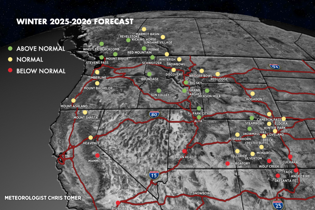
Overall, while this will change day-to-day and week-to-week, my long-range winter forecast for North America favors the northern states out West. I believe we’ll see the most snow, and most consistent snow, in the Pacific Northwest, British Columbia, Western Montana, Western Wyoming, and Idaho. My storm track also favors some of Utah, but only the very northern part in the Wasatch Range. I believe it’ll be a sharp cutoff south of that. In Colorado, it favors Northwest Colorado, including Steamboat and possibly Vail and Aspen Snowmass.
Which Ski Resorts Could Receive The Most Snow?
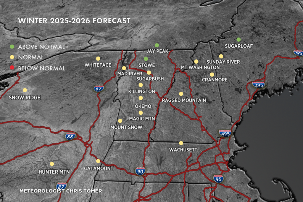
La Niña historically favors the Pacific Northwest, Canada, and northern tier states, and I believe that that will be the case this season. I’m forecasting that the most consistent snowfall will occur at Jackson Hole, Grand Targhee, Big Sky, Sun Valley, Brundage, Schweitzer, Red Mountain, Fernie, Revelstoke, Kicking Horse, Whistler Blackcomb, Mount Baker, Stevens Pass, Crystal Mountain, Mount Rainier, Snowbasin, Powder Mountain, Park City, Deer Valley, Brighton, Solitude, Alta, Snowbird, Steamboat, and possibly Vail and Aspen Snowmass. In the Northeast I’m forecasting the most consistent snowfall at Jay Peak, Stowe, and Sugarloaf.
This could change, but I don’t see this winter’s storm track benefitting the Midwest and the East Coast like it will the West Coast. As the ski season gets closer, I’ll be back with twice-weekly forecasts that’ll be published every Monday and Thursday morning. Subscribe to OnTheSnow’s YouTube page to be notified as soon as those forecasts are published.