The Big Picture
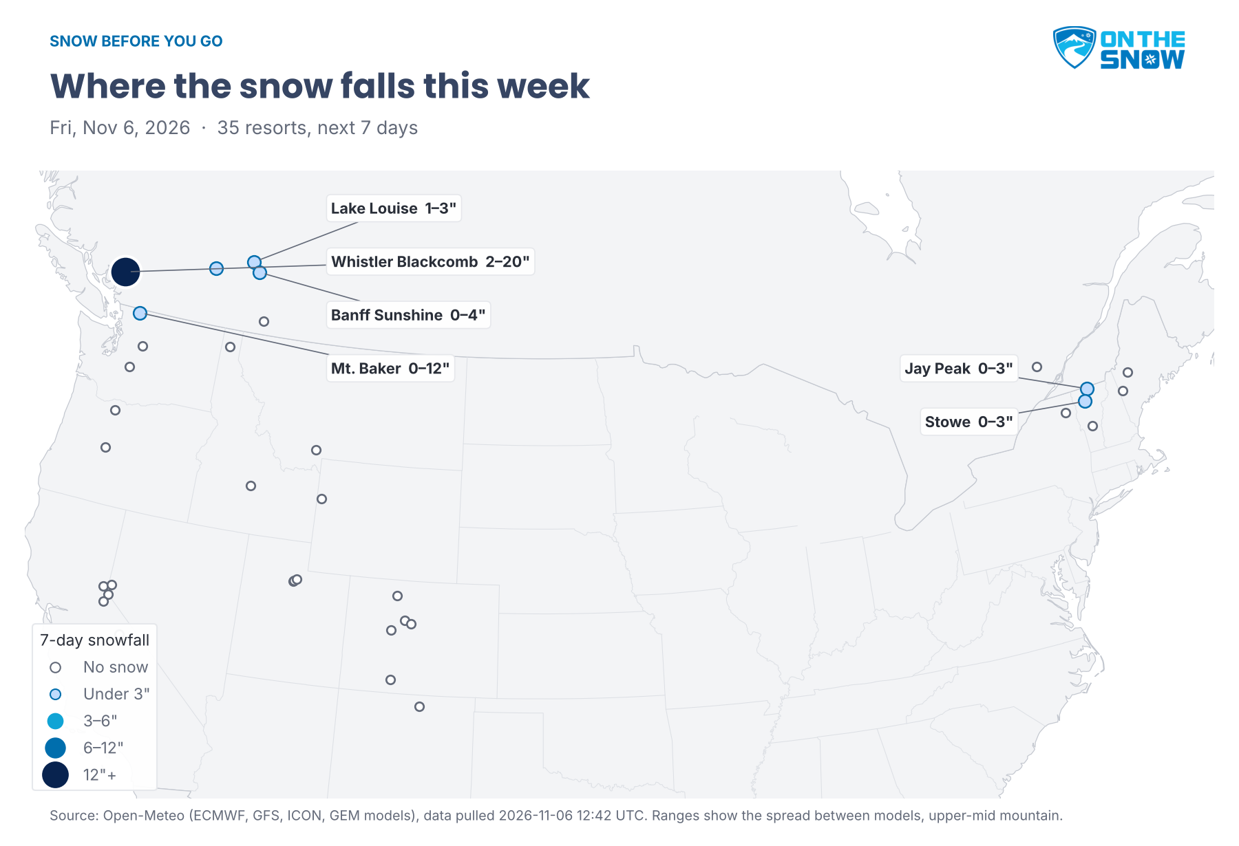
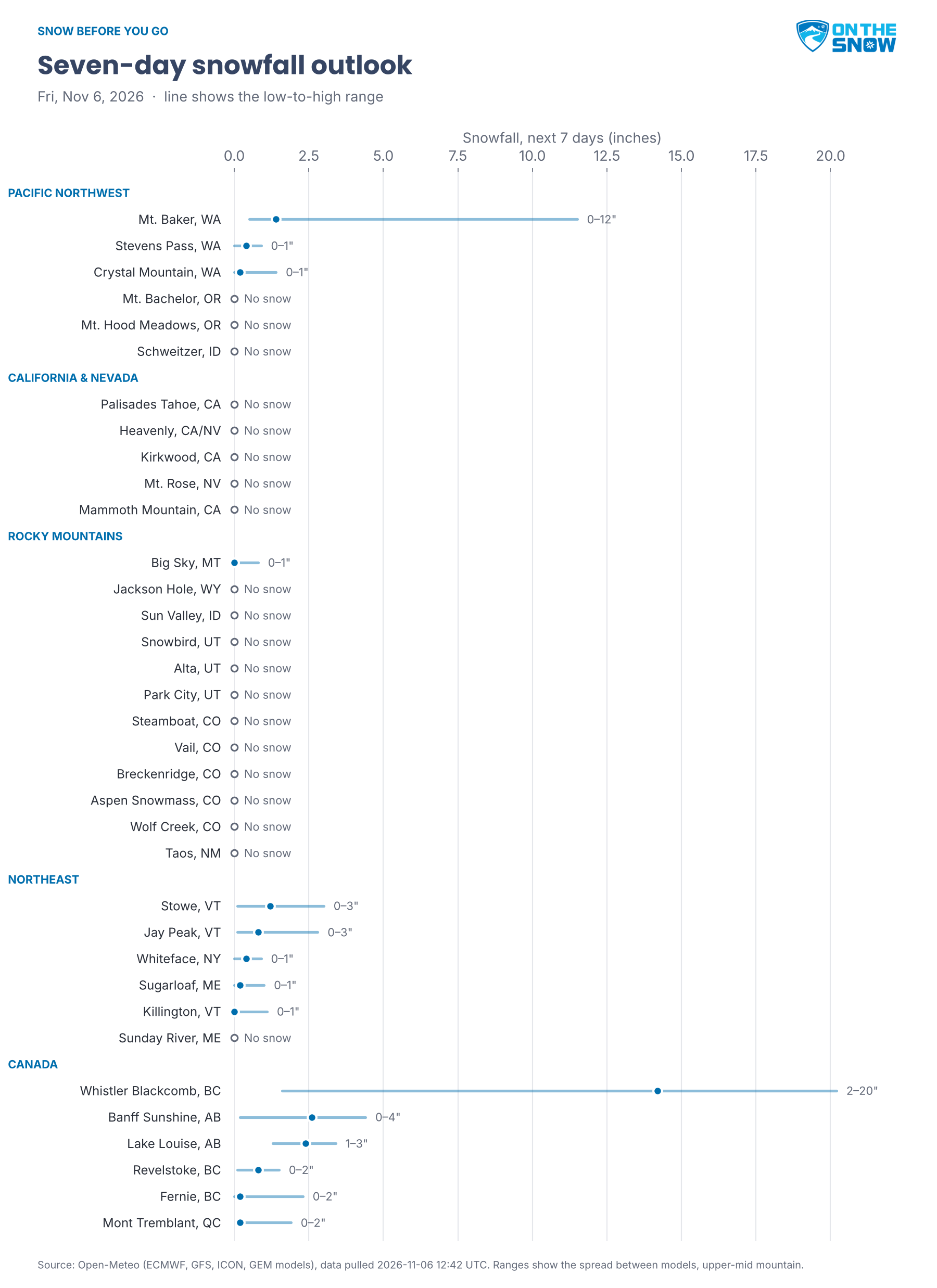
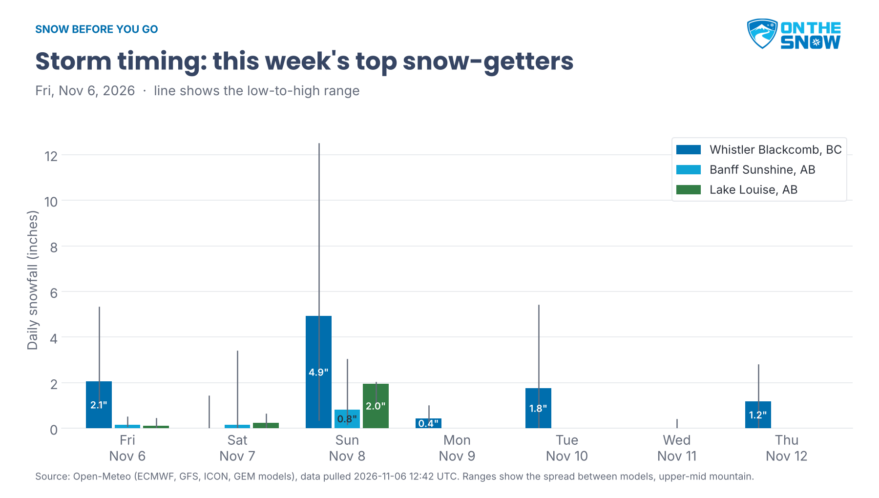
Whistler Blackcomb is again the only place with real snow in the forecast. The week’s total there is anywhere from a couple of inches to about 20 depending on the model, and Sunday is the biggest day. Mt. Baker gets a few inches up high but around 5 inches of rain, and the Canadian Rockies pick up an inch or three on Sunday. The Sierra, Utah and Colorado stay dry and sunny through Thursday, with highs in the 40s and 50s. The Sierra storm that looked promising yesterday has mostly faded: only one model still brings snow next Friday.
Circle Monday at Whistler Blackcomb, when Sunday’s snow meets light winds and a dry sky.
Pacific Northwest
Wet, windy and mostly rain. Mt. Baker gets an inch or two today, up to 7 inches in the snowiest model, and up to 3 more Sunday, but rain is the bigger story: about 5 inches over the week, with Tuesday the wettest day. Saturday is the windiest, with gusts in the 50s. Crystal Mountain and Stevens Pass see an inch at most, mostly Sunday, and up to 2 inches of rain. Mt. Hood Meadows, Mt. Bachelor and Schweitzer stay snow-free. Wind is the risk at Mt. Hood Meadows: gusts near 40 mph Saturday and Sunday, and one model tops 90 mph, enough to hold the upper lifts. Mt. Bachelor gusts reach the 40s both days.
California & Nevada
Dry for the next seven days at all five resorts. Sunshine and a warm-up bring highs near 60 Saturday at Palisades Tahoe and in the mid 50s at Heavenly and Mammoth Mountain through the weekend. Lows in the mid 20s tonight give snowmaking crews a good night, but nights warm toward 30 after that. Winds stay mostly light, with gusts in the 20s. The pattern turns next Friday, covered in Looking Ahead, but the storm that looked likely yesterday now shows up in only one model. Groomers and snowmaking terrain are the play.
Rocky Mountains
Colorado: Dry and sunny for the next 10 days at every Colorado resort in the forecast. Cold nights keep snowmaking going: lows in the mid teens at Breckenridge and Wolf Creek this weekend, and near 20 at Vail. Afternoons warm into the mid to upper 40s at Vail and Steamboat by Monday. Winds stay light, with gusts mostly under 20 mph. Expect firm groomers and manmade snow.
Southern Rockies: Taos stays dry. Highs climb from the mid 30s today to the mid to upper 40s Monday and Tuesday, with lows in the 20s. Gusts stay mostly under 20 mph, with one model near 30 midweek.
Utah & Northern Rockies: Dry all week. Alta, Snowbird and Park City see no snow in any model through the next 10 days. Lows near 20 tonight help snowmaking, then it warms: highs in the mid 40s at Alta and Snowbird Sunday and Monday, and in the low 50s at Park City. Farther north, Big Sky could see up to an inch Tuesday in one model; otherwise it, Jackson Hole and Sun Valley stay dry. Big Sky starts cold, with highs in the mid 30s today, and gusts reach the 30s there Sunday. Sun Valley climbs to about 50 by Thursday.
Northeast
Rain first, then a cold turn. Today is mild, with highs in the mid 50s at Killington and Stowe and near 60 at Sunday River. Saturday brings the steadiest rain, up to an inch at Killington and much more at Sunday River in the wettest model, which totals about 4 inches there for the week. Colder air arrives Sunday, with highs in the upper 30s and up to an inch of snow at Killington and Stowe. Midweek turns windy, with gusts in the 30s and near 40 at Whiteface and Sugarloaf Tuesday and Wednesday, enough to slow the upper lifts. By Thursday, highs near 30 bring up to 2 inches at Jay Peak and Stowe, up to 3 for the week.
Canada
Whistler Blackcomb has the week’s snow, and the models disagree on how much. Today brings 1–5 inches. Saturday turns wet, with up to 2 inches of rain lower on the mountain and gusts in the 40s. Sunday is the big snow day but an uncertain one: anywhere from a trace to a foot, with about 5 inches the middle ground and gusts in the 40s. Monday is the best ski day, with lighter winds and lows near 20. Tuesday could add up to 5 inches, then Wednesday is rainy. Lake Louise gets 1–3 inches, mostly Sunday, with lows near 10 Monday and Tuesday. Banff Sunshine gets up to 4 inches, with gusts in the 40s through Sunday. Revelstoke and Fernie get up to 2 inches, Fernie with gusts near 50 mph Sunday, and Mont Tremblant could see up to 2 inches Tuesday in one model.
Looking Ahead
Days 8 to 10 (next Friday through Sunday) look snowy in the Northwest. Whistler Blackcomb could see powder days Friday and Saturday, with the models split between almost nothing and more than a foot. Mt. Baker and Crystal Mountain pick up several inches Saturday, and Sunday could be a powder day at Mt. Baker; Mt. Bachelor gets a few inches. In the Sierra, only one model brings snow, up to about 8 inches at Kirkwood next Friday, with gusts in the 40s. Big Sky and Sun Valley could see a few inches by Sunday, and the Northeast stays cold, with highs in the mid 20s. Confidence is low this far out.
Forecast data: Open-Meteo (ECMWF, GFS, ICON and GEM models), pulled Nov. 6, 2026, 12:42 UTC (early Friday morning Mountain time), at upper-mid mountain elevation for each resort. Snow ranges show the spread between the four models; where they disagree widely, the text says so.