Prepared by OnTheSnow.com Meteorologist Juan V. Portillo
Banff Sunshine Village posted photos of its first snow of the season on August 30, and on September 26 fresh snow turned the upper slopes of Lake Louise white among the golden larches, as its webcams show. It did not last: the mountain weather stations we checked, from the Cascades to Colorado and the Canadian Rockies, measured no lasting snow up to October 4. September split by region, cool and wet in the Cascades and British Columbia, about 2 C warmer than normal in Colorado, close to normal in Utah and the Northeast. The first big storm is still to come, and September says little about the winter.
On October 8, NOAA’s Climate Prediction Center said El Niño, now under way, has reached 2.1 C above normal in the central Pacific and has a better than 83% chance of staying strong to very strong through late winter. It puts the chance of a historic event at 83% for October to December, stronger than anything since records began in 1950.
You will see El Niño all over ski forecasts this fall, but turning it into a snow forecast is trickier than usual. This El Niño is heading outside its usual range, possibly the strongest on record, and it follows a La Niña winter. That winter the ocean forecast was right: La Niña arrived on schedule, but many of the snow forecasts built on it missed across the West. All ten Pacific Northwest stations in our data finished below their normal snowfall, at a median of 46% of normal.
Knowing the state of the ocean is not the same as knowing where the snow will fall. This year the signal is strong, which helps, but it does not settle the winter.
What makes this winter different?
Three things set this winter apart from the El Niño winters skiers remember.
- It may be the strongest on record: NOAA puts the chance at 83%. All seven past strong El Niño winters were weaker, so the history below is a guide, not a template.
- The wider Pacific is running cool. The three famous El Niño winters (1982-83, 1997-98 and 2015-16) all came with a warm stretch of the wider Pacific, a slower pattern separate from El Niño. Today that pattern is cooler than in any of the seven. In the two strong El Niño winters when it ran cool, 1972-73 and 2023-24, the low-pressure area over the Gulf of Alaska that steers storms toward California was only about a sixth as deep as in the other five. NOAA said in its September 17 outlook discussion that this may dampen the usual El Niño effects. Its October 15 discussion went the other way, saying the cool Pacific’s influence may be minimal next to a very strong El Niño.
- The Sierra is the call to watch. California is the only region we lean toward more snow, and it is the one a cool Pacific would weaken most. Expect a smaller boost than in 1997-98, and more warm storms that bring rain to lower slopes.
Seven winters is also a small sample. The pattern holds best in the far north (less snow) and in the Sierra (more), and least in Colorado and the interior.
Which ski regions could get the most snow this winter?
Of the regions we can measure, only California and the Sierra lean toward more snow. Washington, Oregon and British Columbia lean toward less at low elevations, the East and Ontario and Quebec toward mild weather, and the interior has equal chances.
The first map is our outlook for this winter. The second is history: since 1957-58 there have been seven strong El Niño winters, meaning the ocean ran at least 1.5 C above normal from December to February (1958, 1973, 1983, 1992, 1998, 2016 and 2024). For each one we compared snowfall at long-record weather stations near ski resorts in the US and Canada with the 1991-2020 normal. Switch between the two maps with the buttons above them.
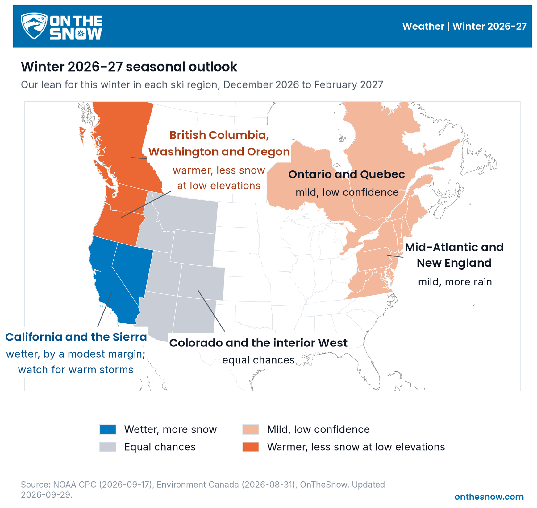
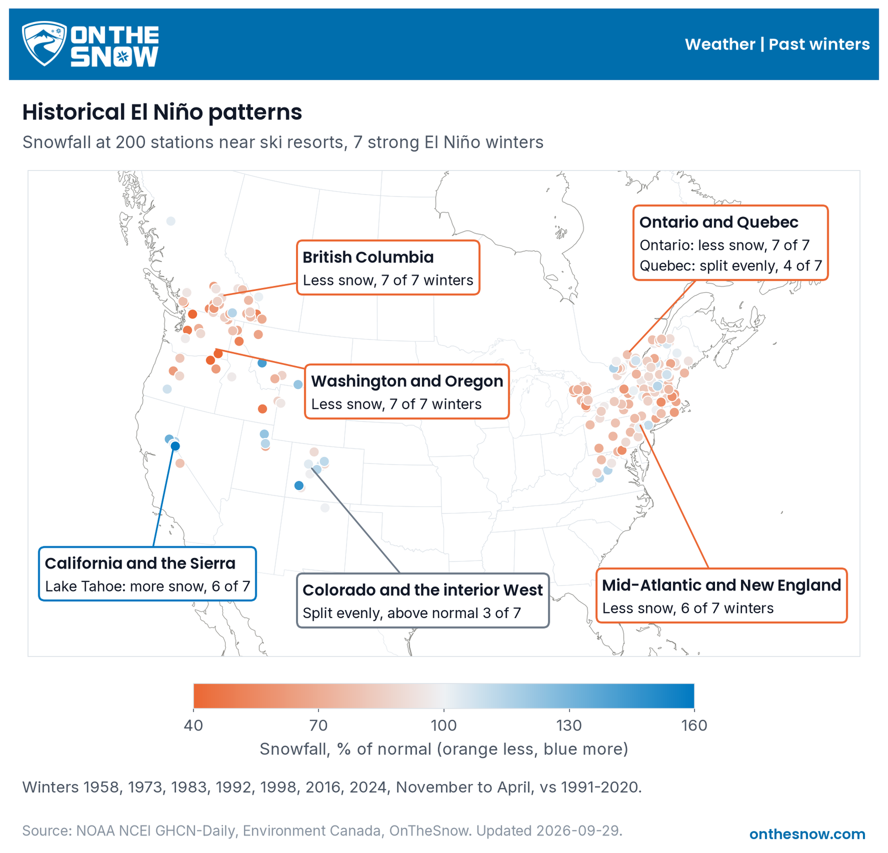
This winter’s lean comes from official outlooks and our own station history. NOAA’s October 15 outlook favors a wetter California, Southwest and southern Plains, and a warmer northern US, with the highest odds of warmth from the Pacific Northwest to the northern Plains, the Great Lakes and the interior Northeast. In the East, expect a warmer north and a wetter coast, which means rain instead of snow at low elevations. The northern Rockies lean drier than normal. Colorado and most of the interior get equal chances, with no lean either way.
In Canada, Environment Canada’s outlook (produced September 30, for November to January) leans strongly warm across the country, with the highest chances in British Columbia, Ontario and Quebec, and precipitation close to equal chances. British Columbia was below normal for snow in all seven strong El Niño winters, so like Washington and Oregon, expect warmer weather and less snow at low elevations. Ontario was also below normal in all seven winters, but Quebec in only four, so we call both regions mild, with lower confidence in Quebec. Alberta’s Rockies have only two long-record stations near resorts, one well below normal and one near normal, too few for a call.
Other regions
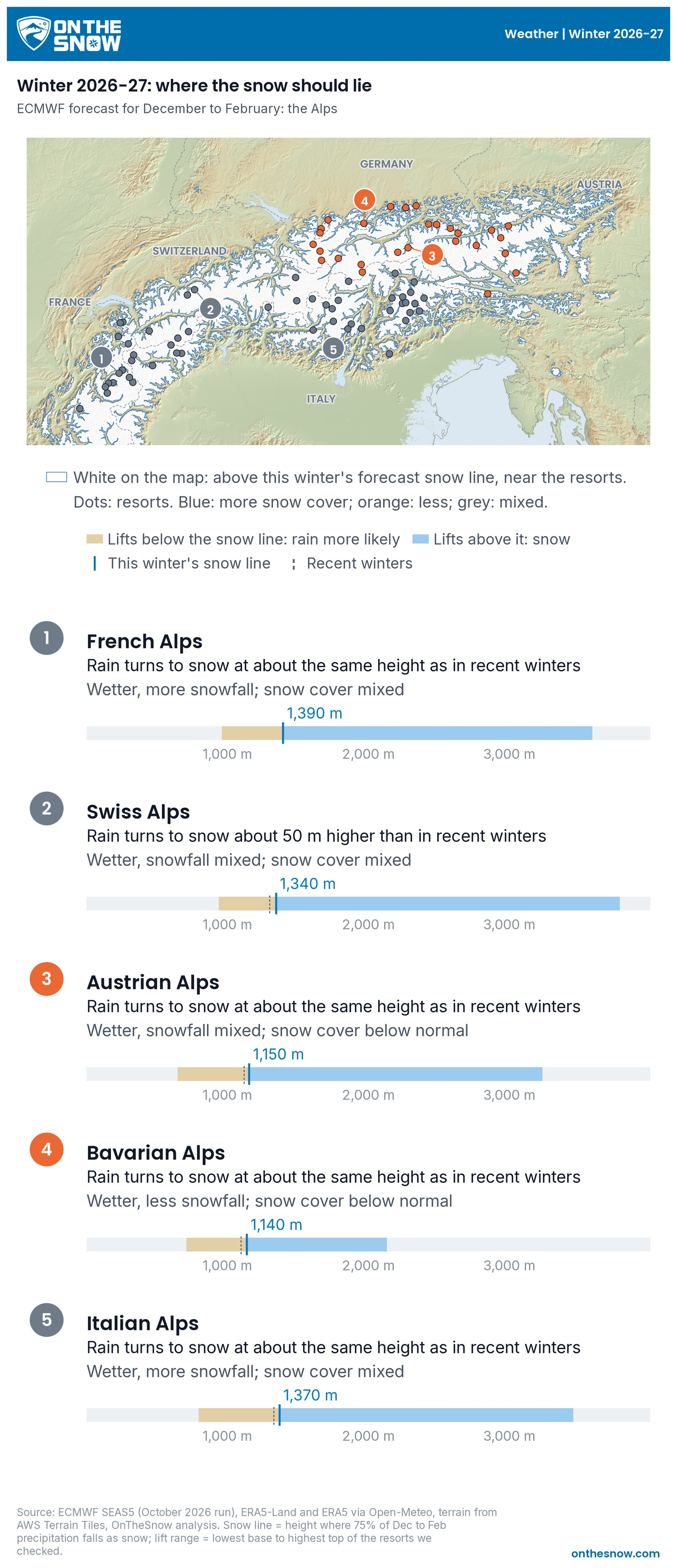
In case you are planning to travel somewhere else, here is what is happening in other regions around the world. Pick a region with the buttons.
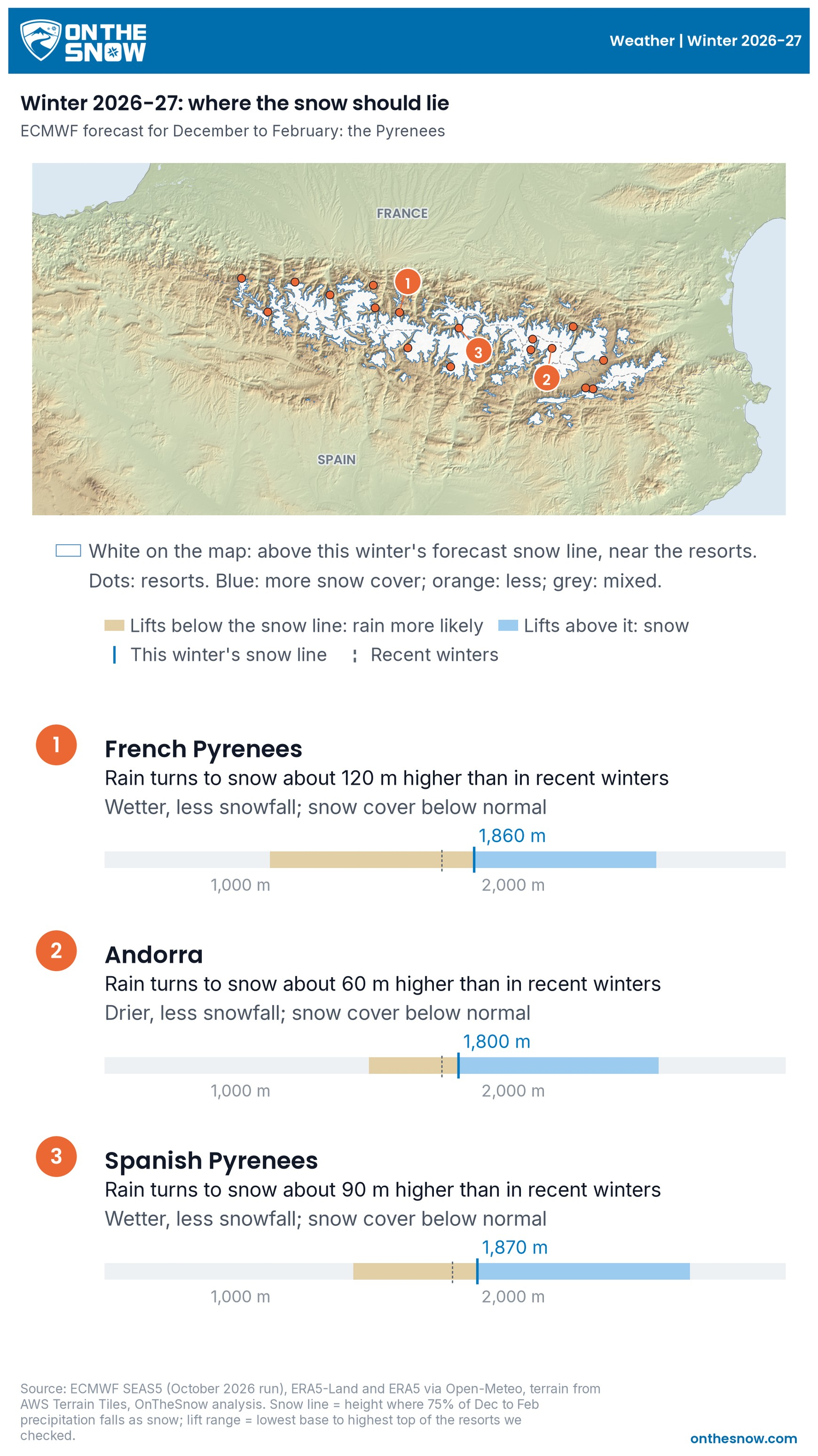
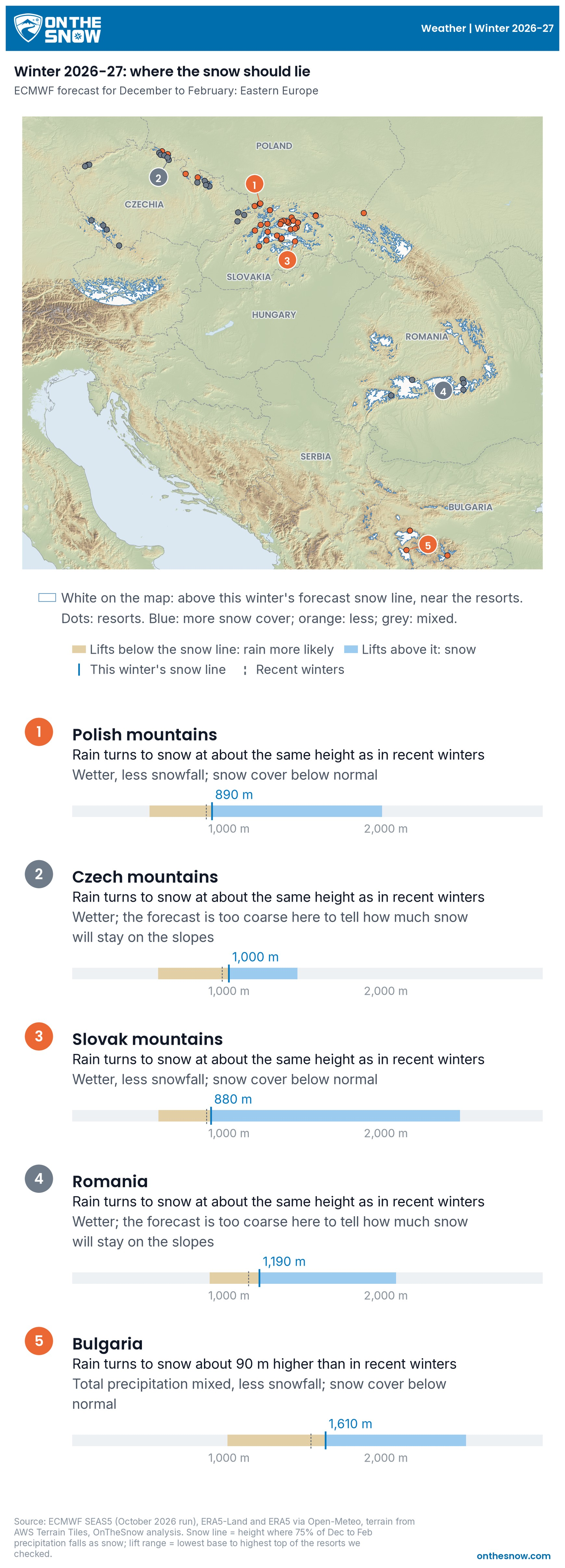
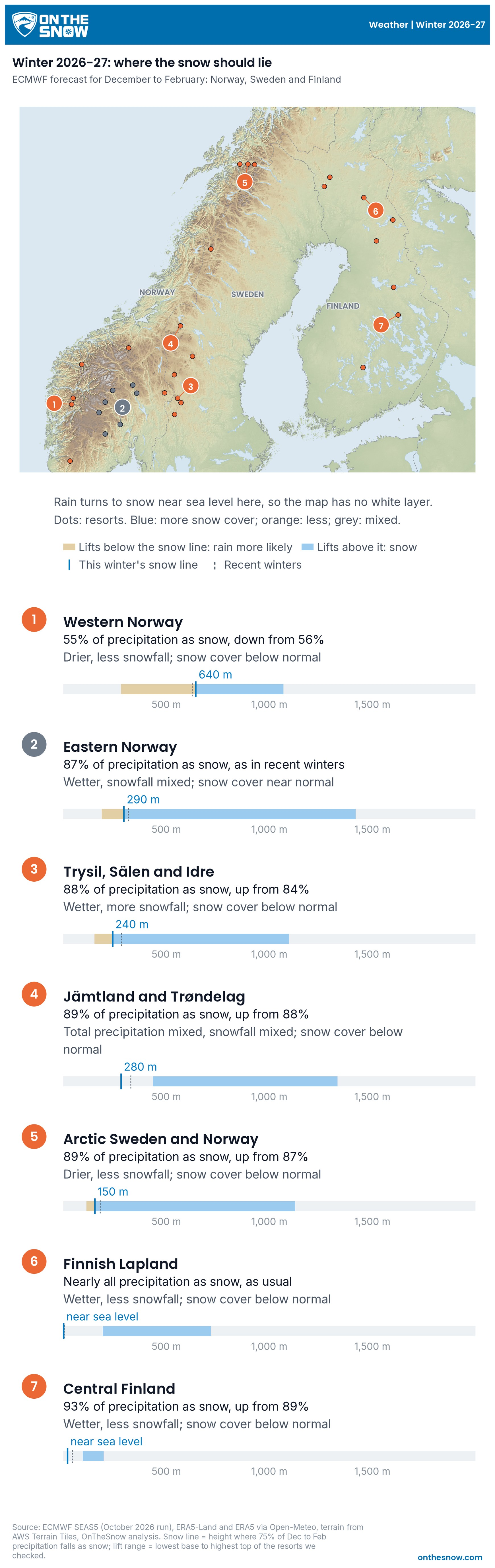
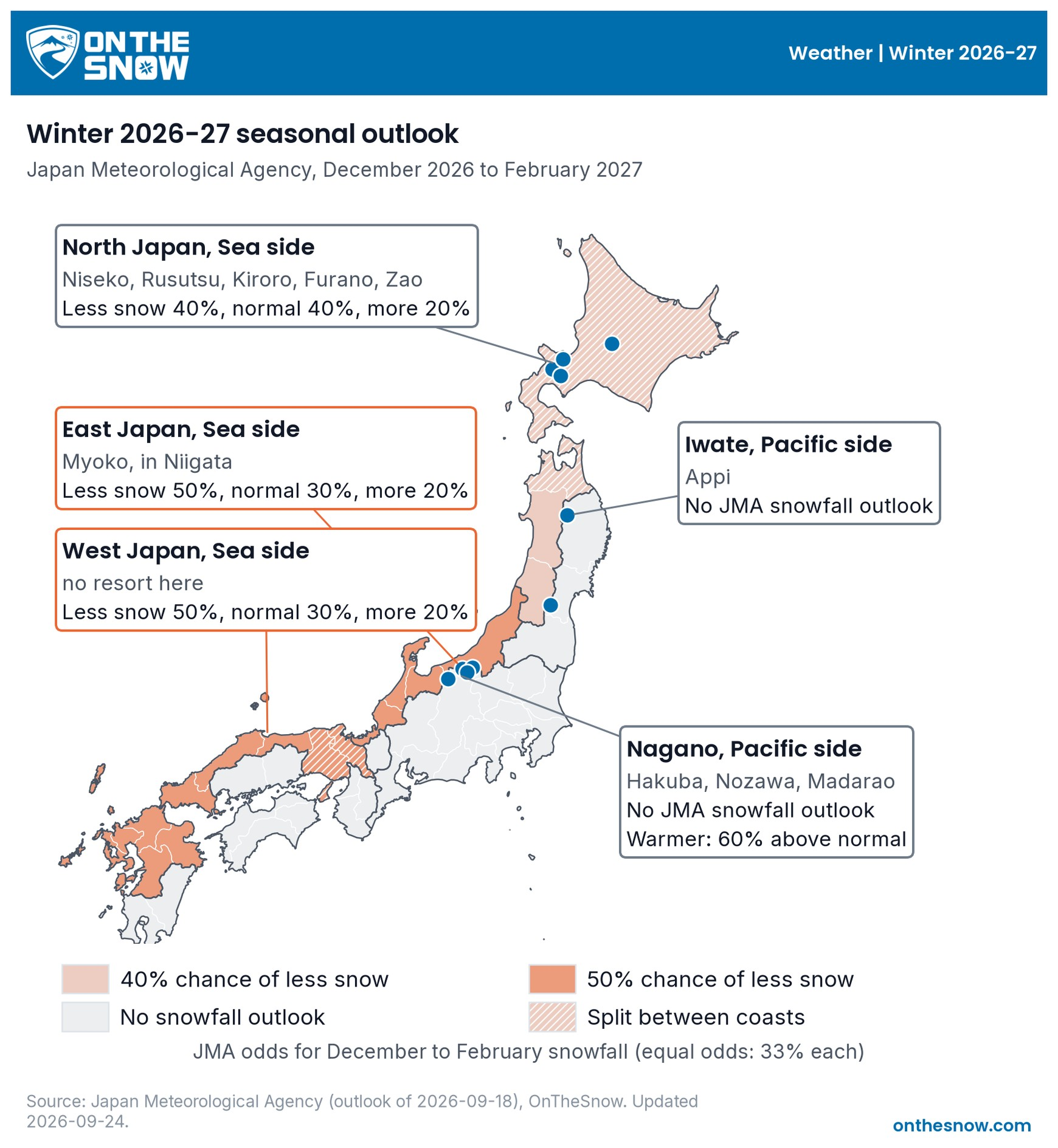
What else decides a ski winter?
Three readings are set for the season. Six more move week to week, and one of them, the jet stream pattern over the Pacific, does the best job of any signal we have tested anywhere at predicting next week’s snow in the Pacific Northwest. The dials show where each stands today and what it does to snow. We update them with this article, and four more get a needle once we can read them daily.
How to read the dials
Each dial is a gauge with a coloured band. Blue means more snow than usual is likely, orange means less, and grey means it is too close to call, a coin flip either way. The needle shows today’s reading, and a faint needle behind it shows last month’s, so you can see which way it is moving. The ring shows the season’s outlook, when there is one.
Set for the season
El Niño
Clear signal for the West Coast and the East, none for the interior.
-
Lake TahoeUsually snowier
-
Washington and OregonUsually less snow
-
Colorado Front Range, interior WestEqual chances
-
Mid-Atlantic and New EnglandUsually less snow
Pacific ocean cycle (PDO)
Likely to shrink the Sierra's El Niño boost.
-
Lake TahoeStill leans wet, but with a smaller boost
-
Northwest coastNOAA now says its influence may be minimal
High-altitude winds (QBO)
A small tilt toward a quiet early winter. With a strong El Niño, NOAA says it favours a stable polar vortex.
-
US East and centralWeak signal next to the short-term dials
Moves week to week
Jet stream over the West (PNA)
Negative favours storms into the West Coast, positive a dry ridge. It is our best guide to the Pacific Northwest's snowfall the following week, fading to nothing by the third week.
Polar vortex
Can turn the East and central US cold one to three weeks after a sudden warming.
Atlantic pressure seesaw (NAO)
Matters most for the East.
Atmospheric rivers
A few storms can make a West Coast season.
Jet stream speed
Sets whether the East and Midwest run mild or cold for up to two weeks.
Blocking highs
Can leave a region dry for weeks.
Grey dials start moving in November, when we can read them every day. Needle: value today. Ring: the seasonal outlook. Bracket: the usual swing between winters. Updated October 19, 2026. Next update November 12, 2026.
When will we know more?
NOAA issues its next El Niño update on November 12 and its next seasonal outlook on November 19, then monthly. Weekly forecasts start again in November. A sudden stratospheric warming can bring the coldest spell of winter one to three weeks later, and the window for one runs from December to February. We will post a check-in in January and review the season in spring.
How should I plan a ski trip around it?
If the signals disagree, keep your dates flexible. If the winter turns out warm, book higher: a high resort keeps its snow when a low one gets rain. Decide as late as you can, and use the weekly forecast for the trip itself, because a forecast one to ten days out has real skill and a September one has very little.
Sources
- NOAA CPC ENSO diagnostic discussion, issued October 8, 2026. NOAA replaces the page each month, so the text quoted here is from that date.
- NOAA CPC seasonal outlook discussion, issued October 15, 2026 and replaced monthly.
- NOAA NCEI PDO index (ERSST v5), data to September 2026.
- NOAA CPC ONI and RONI tables.
- NOAA NCEI GHCN-Daily station records, US and Canadian (Environment Canada) stations.
- Environment Canada seasonal forecasts, temperature and precipitation probabilities for November 2026 to January 2027, produced September 30, 2026. Environment Canada replaces the page each month.