The Big Picture
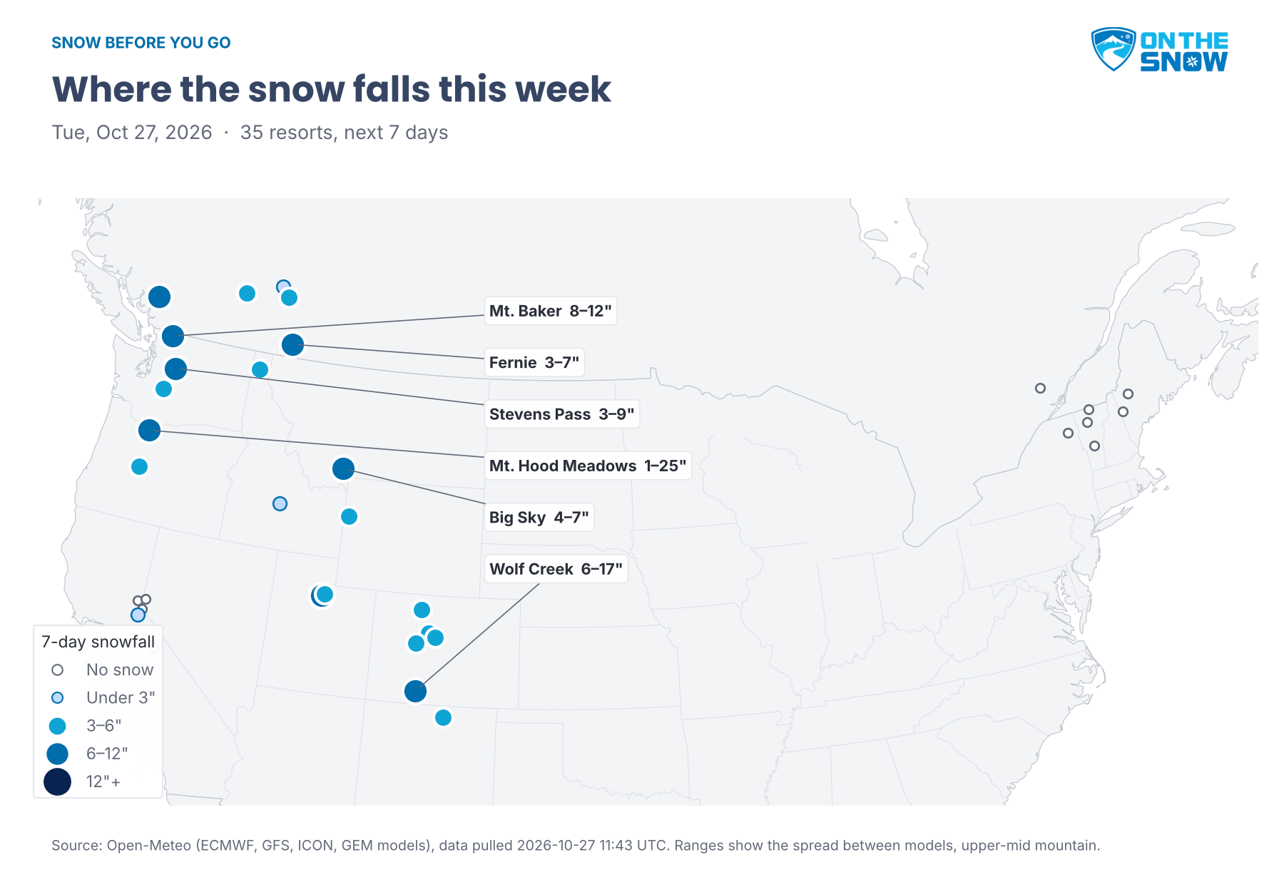
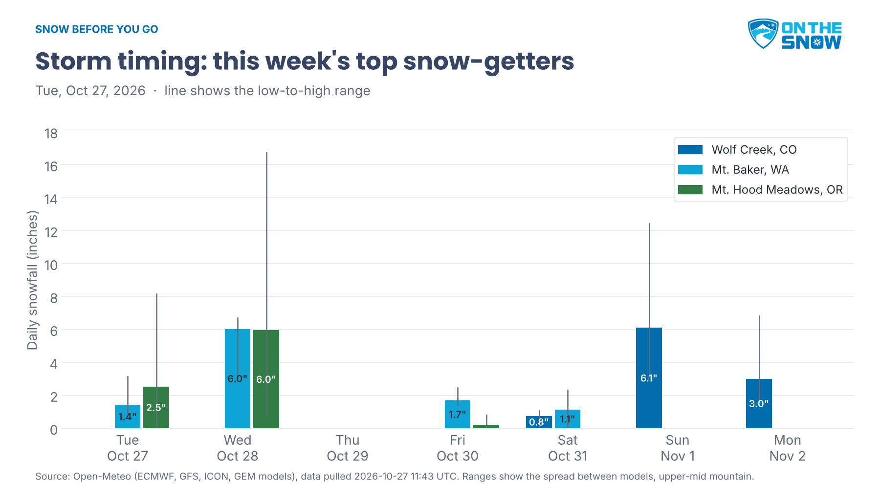
This week plays out in two acts. Act one is happening now: a cold system crosses Washington, Oregon and southern British Columbia today and Wednesday, and Mt. Baker comes out on top with 8–12 inches for the week and a powder day Wednesday. Act two arrives Saturday, when a storm drops into the Four Corners and spreads north through Sunday and Monday. Wolf Creek is the big winner, with anywhere from 6 inches to well over a foot, and Alta, Snowbird, Aspen Snowmass and Big Sky pick up several inches each. California sees only flurries, and the Northeast stays dry and turns briefly warm.
Circle two days: Thursday at Mt. Baker, the first clear morning after Wednesday’s snow, and Sunday at Wolf Creek.
Pacific Northwest
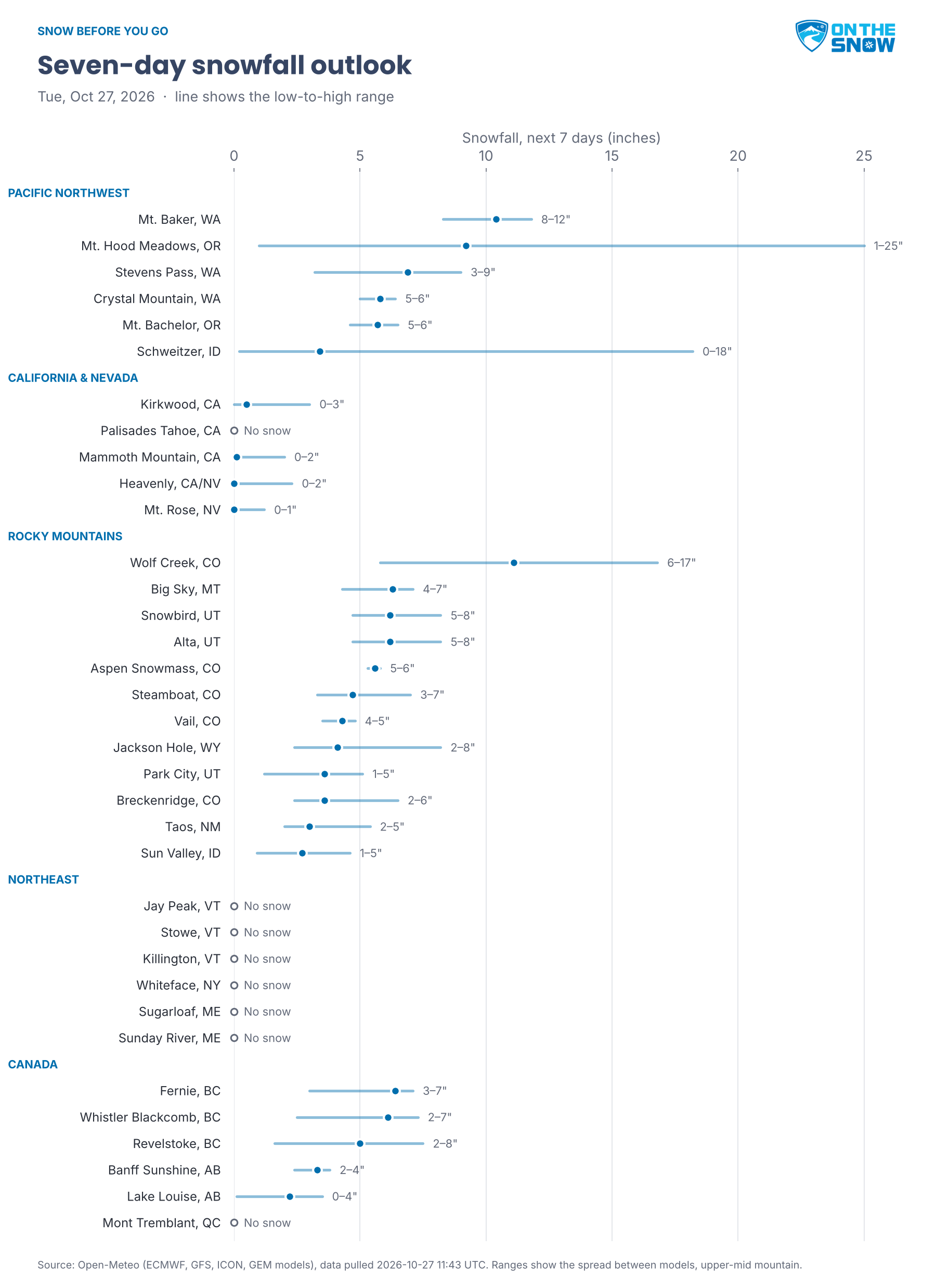
The snow is falling now and wraps up Wednesday. Mt. Baker gets the most, 4–8 inches by Wednesday night and 8–12 for the week, with Wednesday a powder day and a little rain at the base this morning. Thursday is the day to ski it. Stevens Pass picks up 4–8 inches and Crystal Mountain and Mt. Bachelor 3–6, mostly Wednesday. Mt. Hood Meadows is the hard call: the models range from an inch to about 2 feet, and gusts near 40 mph today and Wednesday could hold upper lifts. Schweitzer mixes rain with wet snow and is just as uncertain. Thursday on turns dry and cold, with lows near 20.
California & Nevada
Dry for the next several days. Gusts of 35–40 mph blow across Kirkwood, Heavenly, Palisades Tahoe and Mammoth Mountain today, then the wind eases and highs climb to the upper 40s Wednesday. A cooler trough brushes the Sierra Saturday and Sunday with highs in the mid to upper 30s and a few flurries: a coating to 3 inches at Kirkwood, a coating to 2 at Heavenly and Mammoth Mountain, and an inch or less at Mt. Rose. Palisades Tahoe stays dry. It warms again early next week, with highs in the mid 50s by Tuesday.
Rocky Mountains
Colorado: Four mild, dry days with highs in the 40s, near 50 at Steamboat, then a sharp turn. Wolf Creek gets the first and biggest share: snow starts Saturday, Sunday is the powder day at 3–12 inches, and Monday adds 2–7 more, so call it 6 inches to well over a foot with the models split on the high end. Gusts of 35 mph Monday and Tuesday could slow lifts. The storm reaches the central mountains Monday with a few rain showers first on Sunday: Aspen Snowmass picks up 4–8 inches, Vail and Steamboat 3–6, and Breckenridge 2–6, where gusts reach the low 30s and lows drop near 10 by Tuesday.
Southern Rockies: Taos stays dry and mild through Saturday, with highs in the mid 40s. Rain moves in Sunday, 0.3–1.1 inches in all, then turns to 2–4 inches of snow Monday as highs fall to about 30.
Utah & Northern Rockies: Alta and Snowbird stay dry and windy through Friday, with gusts near 35–40 mph today and Wednesday. Rain arrives Saturday, then the storm turns cold Sunday: 4–8 inches by Monday, most of it Sunday, with highs dropping to the mid 20s Monday. Park City sees rain Saturday and Sunday before 1–5 inches of snow. Big Sky gets a light refresh today and its main shot Sunday, 4–8 inches for the week, with lows near 5 Monday. Jackson Hole and Sun Valley mix rain and snow Friday through Sunday; the models range from a coating to several inches at both, so the forecast is uncertain.
Northeast
No snow anywhere in the region through next Thursday. Today and Wednesday stay cool, with highs in the 30s and 40s, then a warm surge Thursday pushes highs into the mid and upper 50s at Jay Peak, Stowe, Killington and Whiteface and near 60 at Sunday River. Light rain showers and gusts of 30–35 mph come with it Thursday and Friday. Saturday cools back to the mid 30s to 40 at Sugarloaf and Jay Peak, but the air stays too dry for snow.
Canada
The same Pacific system reaches British Columbia and Alberta today and Wednesday. Fernie picks up 3–6 inches, Whistler Blackcomb 2–6 and Revelstoke 2–7, with Wednesday the snowiest day and Thursday the best day to ski at Revelstoke. Banff Sunshine adds 2–4 inches and Lake Louise a coating to 4. Deep cold follows: lows near 5 at Lake Louise and Banff Sunshine Thursday and Friday, with highs in the 20s, good news for snowmaking. The rest of the week is dry. Mont Tremblant stays snow-free, with highs near 55 Thursday.
Looking Ahead
Days 8 to 10, next Tuesday through Thursday, look quiet across most of the West, with cold mornings in Colorado behind the Monday storm and highs in the mid 50s in the Sierra. Light rain returns to the Cascades and Whistler Blackcomb next Thursday, and the Northeast still shows no snow. Confidence is low that far out.
Forecast data: Open-Meteo (ECMWF, GFS, ICON and GEM models), pulled Oct. 27, 2026, 11:43 UTC (early Tuesday morning Mountain time), at upper-mid mountain elevation for each resort. Snow ranges show the spread between the four models; where they disagree widely, the text says so.